3 Results
A summary of the results is shown below in Table 2. A comparison is also made with the results of the site visits in the pilot study. Detailed results for each road link are shown in Appendix 1. The figures in Table 2 are estimated numbers of residential buildings, based on the assumption that residential buildings are those address points with no building name. This does however conceal some uncertainty because there may be buildings of non-residential use that also do not have names. This issue is considered further in the next section on sources of uncertainty.
Table 2 Summary of results
|
City |
Number of links analysed |
Number of households found in site visits in pilot study |
Number of households estimated in this study (range based on varying road width assumptions) |
Comments |
|
|
Birmingham |
16 |
59 |
260 |
453 |
The current analysis has identified more houses than found in the pilot survey. A large number of addresses suspected to be non-residential especially on city centre links. |
|
Bristol |
7 |
0 |
17 |
20 |
All links are in commercial areas, therefore most addresses likely to be non-residential. |
|
Doncaster |
2 |
0 |
2 |
2 |
Good correspondence. |
|
Glasgow |
3 |
0 |
6 |
13 |
Good correspondence. |
|
Hull |
3 |
0 |
66 |
76 |
Houses identified very near to end of road, may have been missed in the pilot survey. Also houses in adjacent roads are very near this road. |
|
Leeds |
9 |
50+ |
41 |
41 |
Good correspondence. |
|
Leicester |
6 |
6 |
54 |
55 |
This total includes a block of 24 flats. The links are all on a city centre ring road identified as commercial land use. Many of the points selected are therefore thought to be non-residential.. |
|
Liverpool |
16 |
860+ |
485 |
642 |
Roads with large numbers of houses correspond well with previous results. |
|
London (A406) |
18 |
215+ |
373 |
497 |
Large numbers of flats included in this total. Also one link were houses were found to be within 10m in this study but not included in pilot. Otherwise good correspondence. |
|
Manchester |
12 |
95+ |
103 |
152 |
The current analysis has identified houses within 10m that were not included in the pilot survey. |
|
Newcastle |
4 |
0 |
344 |
378 |
A large block of flats is included |
|
Portsmouth / Fareham |
3 |
6 |
10 |
13 |
Good correspondence. |
|
Sheffield |
3 |
0 |
22 |
23 |
Possibly non-residential buildings. |
|
TOTAL |
2000+ |
||||
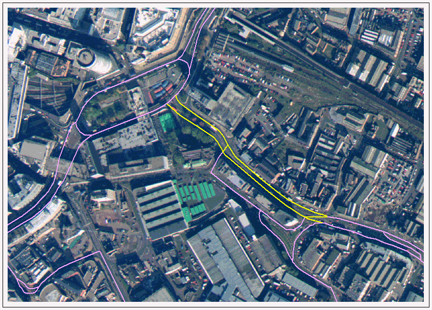
The analysis of the aerial photos provided some additional information. Figure 7 shows the photograph of the centre of Birmingham with the OSCAR data overlaid. Link 57191 is highlighted in yellow. The photo shows that large commercial and industrial buildings dominate the area. In contrast, Figure 8 (link 16365 on Tyburn Road) shows mainly residential buildings with gardens. The south side of the link is commercial.
Figure 7 Bull Ring (link 57191) in Birmingham
Figure 8 Tyburn Road (link 16365) in Birmingham
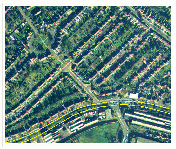
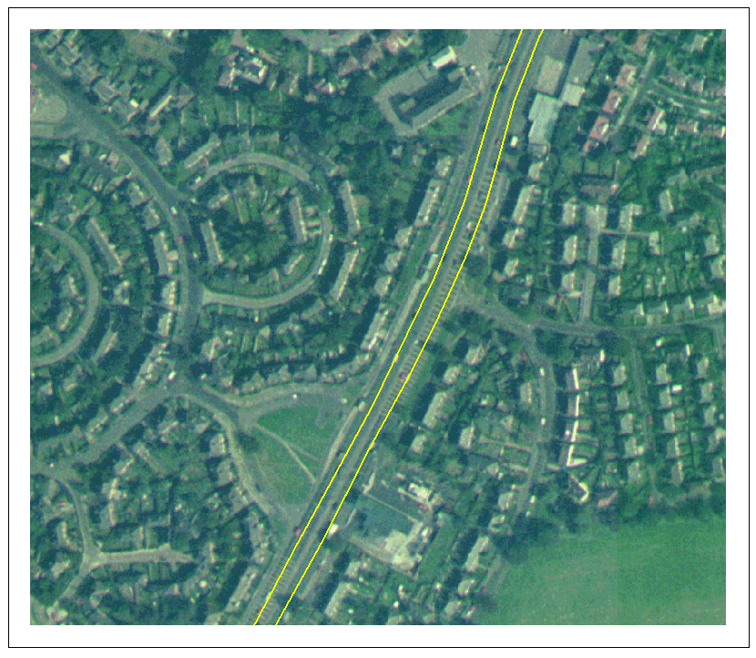
Figure 9 shows the large number of houses close to the North Circular Road on link 37113. Although the picture is not very clear, the variable road and pavement widths can be seen. Figure 10 shows part of link 37809, where no houses were found within 10m of the road in the pilot study, but between 27 and 43 have been found in this study.
Figure 9 London, North Circular Road (link 37113)
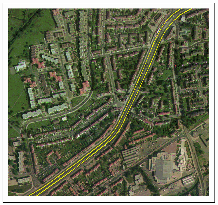
Figure 10 Manchester, A5103 near junction of M63 (link 37809)
3.1 Sources of uncertainty
The description of the method included some discussion of the problems encountered with the digital maps and address point data. These problems may account for some of the disparity between the results of these two studies. Brief explanations of the possible sources of uncertainty in the new method are listed below. Appendix 1 also includes comments on individual road links.
Selection of buildings within 10m of the kerb:
OS Landline data does not represent buildings as polygons and therefore it is not always possible to select individual buildings within the 10m zone. For example, whole terraces of houses may be selected. As far as possible this was corrected for by visual inspection of the selection in the GIS.
Variations in road width, slip roads and access roads caused problems in the calculation of the distance of the houses from the kerb. A range of values for the road width was used and this provided a range of possible households exposed. The aerial photographs did not provide any additional data that can improve this method. A possible solution would be to make individual measurements from the landline data between each house and to the road. This would clearly be very time consuming.
The OS Landline data provides no vertical distance information. For example the road could be a flyover or underpass and therefore the actual distance of buildings close to the road is greater than is shown on the map. No solution has been implemented for this problem.Selection of Address Points within selected buildings:
Because of the nature of the Landline data described above, address points could not be selected on the basis of being 'inside' a building. Therefore all Address Points within a distance of 5m of selected building outlines were selected.Residential Address Points:
It was assumed that Address Points without a building name are residential. This assumption may have provided an over-estimate where there are non-residential buildings that are empty or where no name is given in the database. In some cases such errors could be identified and corrected, such as where surrounding buildings were obviously commercial rather than residential, but in others it was not possible to make the distinction.Blocks of flats:
Address points with flats or apartments are often represented by a series of points all at the same grid reference. The exposed households are those at ground level and possibly first floor level, but it is not possible to determine how many of the flats are at these levels. In these cases, all addresses are included.Inaccuracy in the original survey:
Inaccurate distance measurements in the pilot study may have resulted in uncertainty in the exposures. For example, overestimates of distances would have resulted in buildings not being counted in the pilot.
Chapter 2 Chapter 4
Report and site prepared by the National Environmental Technology Centre, part of AEA Technology, on behalf of the UK Department of the Environment, Transport and the Regions